For the regular readers you will have seen that I have had a project ongoing for quite a while now. It’s good to have multiple projects on the go at anyone time, something I will do regularly. This project is about the Companion Stones that are dotted about the Peak District. I have 3 more of the 12 to take images of and last Saturday morning I set off to capture at least 2 of the last 3.
The Companion Stone website has the exact location of each stone and these can be plotted on an OS map. that’s exactly what I have done and each one is noted on my phone, so I can find them whilst in the field so to speak. Looking at the OS map 2 of the last 3 were quite close together, on Beeley Moor. One of the two is named after the English Heritage site, Hob Hurst’s House, an ancient burial ground. So off I went in search of the stones.
Hob Hurst’s House.
Beeley Moor is situated just above the village of Beeley, hardly a surprise I guess. The drive down was lovely, it was a nice sunny day and the sat nav took me through the road that passes through the grounds of Chatsworth House. Once I found Beeley I was getting excited. My hopes where dashed as the main road up onto the moor was closed, bloody road works. A quick review of the OS map and I realised that a de-tour would take me to the exact point I needed to park, just via a circuitous route.
Hob Hurst House Stone
The walk from the car was well sign posted both on the OS map app and along the route on the small posts that you find on access land. My first line of sight to where the stone was on the map was up a fairly steep hill, and through some rocky sections to. Thankfully the map showed a trail that led around the paths, over a few fields and followed the line of a small plantation of trees. Even my weary bones could manage the hike up. I had my carry around camera (Sony A6600 with the 16 to 55 f2.8 G Lens) with me so its a lot less heavy than my full kit. On a warm sunny day I was grateful for the smaller backpack. Eventually I reached the English Heritage site and saw in the distance the stoop stone that is a tell tale sign that the first of the stones wasn’t far away.
The stoop and the stone
The concept of the companion stones (amongst other things) is that it rests near a stoop stone. A wayfinding stone in days gone by. These helped travellers on the Peaks to know the way and how far they were from various locations. Each stone has its only story and wording, and the full details of these can be found HERE. You get a sense of how isolated the stone is from this image, as you can see the stoop stone and the sweeping Moreland behind it. Thankfully it’s not far into the moorland wilderness, although I wouldn’t want to be caught up on this moor without appropriate gear.
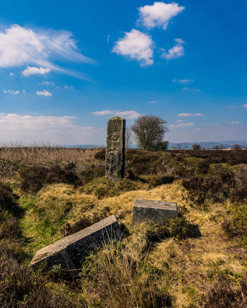
Beeley Moor Stone
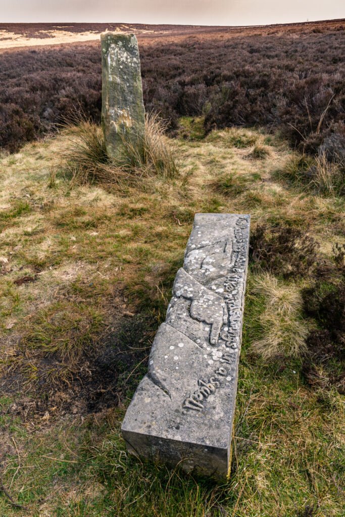
Having retraced my steps back to my car, I was really quite hot and I was grateful that I’d not used a bottle of water the last time I played golf, which was sitting in the boot of my car. I always take water on walks with me, but it was so hot that the first one went half way back to the car. Having rehydrated, I typed the next location into the OS map app, and sure enough the 2nd stone was only about quarter of a mile along the same road. This time it was very close to the road, and again it was the stoop stone that I spotted first.

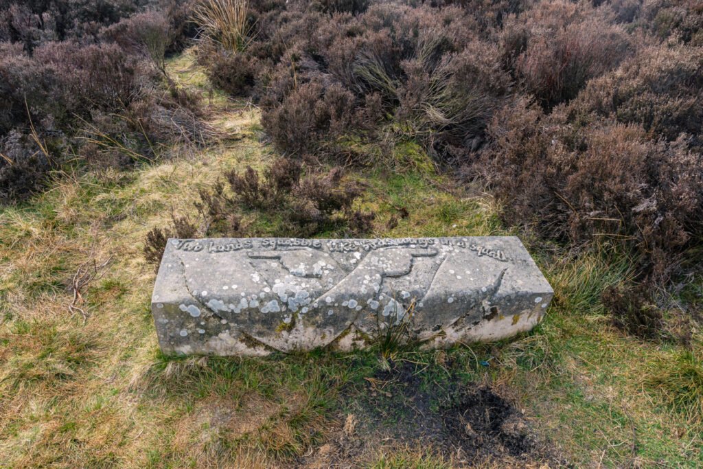
I pulled over to the side of the road and pulled out my camera. No need to carry the backpack, I’d only taken handheld shots of the first stone. This one would be the same. As you can see from this image it looks like the stone has been knocked over, or in some way vandalised. Not ideal I though but I decided to take the images as the stones lay. If you zoom into the image you can see that the words on the square block stone talk about stones laying where they fall. If I’d had cared to read that on site, I probable wouldn’t have been as disgruntled that someone had delibertately done something to damage the stone. Clearly a lot more research is required into each stone and I will do this when I come to do the formal write up of the project. Interesting stuff for sure.
You can see from this second image why I would think that it was knocked over. On reflection and looking back at the images there isn’t anywhere on the square block where the other stone would sit. What you can also see on this second image is the stoop stone, as well as the stones in the context of the landscape. Whilst it doesn’t look like it there is actually a road just behind where the tree is in the background. I spent about 40 minutes looking at the stones and taking alternative views, and what struck me was how busy the road was. Lots of cars but an absolute dearth of cyclists. I guess its this part of the world that attracts cyclists, long relatively empty roads with stunning views. Whats not to love.
There is one stone left. The wonderfully named Deadshaw Sick stone. This last stone will be for another day, I needed to head off home, to watch the football and prepare for my first night in a pub for a long time. Not exactly inside a pub but you know what I mean. Me and the lads met for a few beers and some much needed chat. It was a great day. Once I have images of the last stone I will be doing a formal end of project write up and this will appear in the Projects section of this website. Keep your eyes peeled for that.
An area I know quite well, but lots of interesting information that I was quite ignorant of! Great pictures too.
Thanks carol 👍🏻 it’s a lovely part of the country