I really need to find out exactly how many “edges” there are in The Peak District, so I can keep a tally against that list. What I do have is a list of places I’ve researched and I’m working my way through that methodically. Well in truth, it’s about what takes my fancy on a week by week basis.
I’m really not going to find out how many reservoirs there are, I’m thinking there are many more than I ever anticipated there would be, and that’s just in my neck of the woods.
Torside and Rhodeswood Reservoirs
I’ve actually been to Torside Reservoir earlier in the year, well before lockdown. In all honesty I set off on Friday with the intention of going back onto Stanage Edge. However, Friday didn’t quite go to plan. What with a new smart electric meter needing to be fitted and having to do some domestic things, I didn’t set off until about 1.30pm.
Why I was surprised at the volume of traffic I’ll never know, but there was a lot and I wasn’t in the mood to sit in huge traffic queues. So a detour took me through the wilds of Marple. As I drove I hatched a plan to go somewhere different, Chinley was the place that I headed for, and lovely it is to. I will have to research where things are as I didn’t really find what I was looking for.
What I did find was a road that took me towards Glossop, and I thought I’d head down the Woodhead pass and find something down there. Why I pulled into Torside car park I’m not sure, I guess I was fed up and wanted to get taking pictures.
My Viewranger App told me that the Longdendale Trail went through this area, and I had seen the reservoir overspills as I drove along the road. My plan was set, more long exposure practise but this time on reservoir overflows. Good plan I thought.
As I walked along the access walkway through Torside and Rhodeswood Reservoirs a few things caught my eye, and so out came the camera. Bear in mind I’d been walking for 30 minutes at this point, that is unusual for me. The first image here is of a small overflow that has a long trench that connects the two reservoirs together. There are several of these oversteps along the way but the longer trench appealed as I could use the longer end of the lens focal length and test the long exposure at the longer end of the range. I like this image and it was the 3rd one I took and with the “Big Stopper” to give a longish shutter speed. I like this.

The Overflow Trench
By the trench and I could also hear more running water so I decided to set off to find the other end of the trench that led into Rhodeswood Reservoir. There are more steps on the overflow of this second shot but sadly there is also a huge pipe, but I couldn’t find a place where the pipe wouldn’t be in the shot.
The second image is again using the “Big Stopper” and I really like how all the bubbles that eddy around at the bottom of the steps all look very “milky” in a very dark lake.

The Milky Bubbles
Whilst the camera was taking the long exposure, I decided to have a look over the wall behind me, and what I saw is captured in the third image. This is very much open water, but I like the textures on the water, aided by the circular polariser. You get a sense of how big the place is from this shot and some of the surrounding scenery.

Open Waters
At this point I was full of enthusiasm for more overflow steps and the one I’d spotted from the road did not have a huge pipe across it. So off I went completely oblivious to the signs all around the path as I walked. I should have read them.
As I got to the access road on the other side of Torside Reservoir, I was greeted with huge temporary fencing, and signs saying that improvements where bing made. This meant I’d walked the whole way round for nothing, and to make it worse I had to walk all the way back again. That will teach me to read the signs!!!
I did notice a lovely viewing point as I trudged back round the reservoirs, so decided to take a sweeping shot of Torside and the surrounding hills off into the distance. This forth image shows what a gorgeous view there is to be had and a nice picnic could be taken on the bench that is provided.

Gorgeous View
I have to say my feet hurt when I got back to my car, and I was so grateful that I had bought 2 drinks from the shop earlier, and one was waiting for me in the car. 11 kilometers walked with my camera pack on my back and I didn’t get the shot I was after!!
Birchen Edge
Birchen Edge sits not far from Curber and Baslow Edges, but as you approach it you’ll be forgiven for not spotting it. It really is nestled away in amongst the Silver Birch trees. I managed to squeeze my car into the last spot in the car park, and set off up the path. I really didn’t know where I was going or what to expect, but I pressed on regardless. The Viewranger App showed me a set of footpaths as well as a suggested route, and apart from some scrambling up the last 20 yards or so, it’s a relatively easy route up.
Well I say up, at the top of the scramble path, there was just more ferms and silver birch, but after consulting the map again, it was obvious where the route was and the edge was not far along through the ferns.
As the edge came into view I was struck by how many climbers there where, both on the paths and on the rocks themselves. Now this might just be because it’s a smaller outcrop, or it’s a popular spot but there where a good few climbers.
The view out from the top of the edge opened up and it is a glorious sight back down over the valley, and the first image here has a focus right out on a single tree at the end of a long windy path. Focusing so far out means that the things closes to the camera are not in focus, this is depth of field. I like this image a lot.
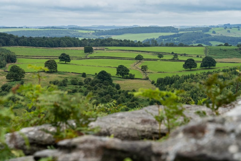
Depth of Field
A google search told me that there was a monument to Nelson on the edge somewhere, and this came into view as I walked further along the path. It’s a an old monument but has a lot of weather wear over the years. Having said that there is a plaque and before I could read it an elderly gentleman told me the story of Nelson and his ships and the rocks behind the monument are all named after his ships. More on that soon.

Nelson and The Climber
There were climbers of all ages, shapes and sizes all over the outcrops and the three rocks bearing the name of Nelsons ships are ideal for bouldering (the art of scaling a bolder without ropes and other climbing stuff). As I got nearer the rocks you can see the names of the rocks have been carved into them.
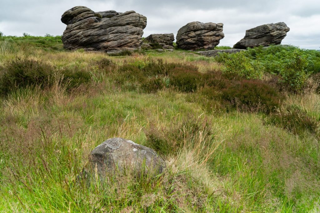
The Three Ships
Lord Nelson’s most famous ship is of course called “Victory” and the largest of the boulders carries the name “Victory”. These types of rock formations are all over The Peak District, but why these three carry the names of Nelson’s ships I do not know, I should have asked the bloke!!
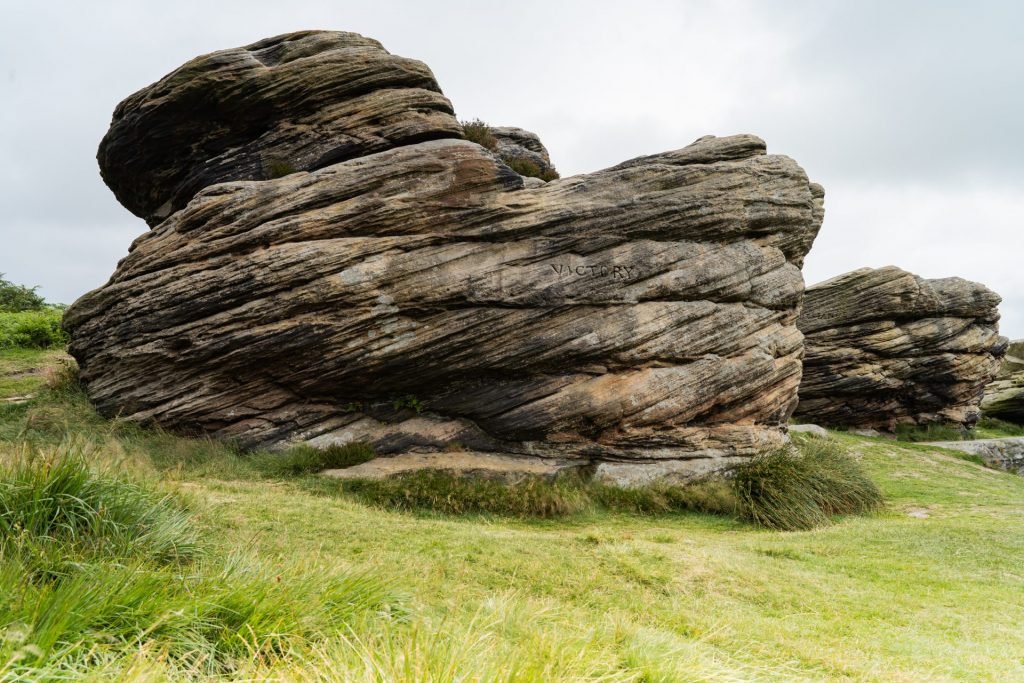
“Victory”
As I looked out over the Derwent Valley I could see the weather was closing in and it was time for me to head back to the car for lunch and to make sure I didn’t get caught in the rain. You could say I’m a fair weather photographer!! The last image shows the views out across the valley, this is a special place for sure!

Derwent Valley